


وصف لـ Surveying Calculator
Surveying Calculator has commonly used land surveying tools. This includes coordinate geometry calculations, offline point data collection, displaying CAD, GIS, raster data and online maps in QGIS 3 project format. Surveying Calculator supports QGIS 3 projects. (qgs, qgz)
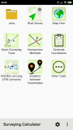
Features:
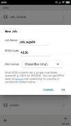
- Jobs:
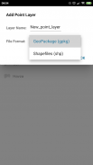
→ Create unlimited jobs for collecting points in SHP or GeoPackage formats with coordinate system code (EPSG code).
→ You can also prepare a job in QGIS on desktop with geospatial data. Import CAD, GIS, raster data or add online map services in QGIS. And transfer the data folder to Surveying_Calculator/projects folder on your device. Select the project in Jobs and Start Survey.
- Start Survey:
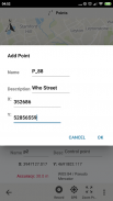
→ Collect unlimited points with "name" and "description". You can record your location or any place you want.
→ Add point with coordinates ( x, y or latitude, longitude).
→ Make surveying easy using QGIS projects.
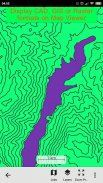
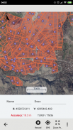
- Map Viewer: Displays QGIS 3 projects.
→ It is possible to include geospatial data to display maps on this app;
→ Raster (GeoTIFF, DEM, JPEG, PNG, GRD, XYZ, ..),
→ CAD (DXF, DGN v7),
→ GIS (ArcGIS shp, Google Earth (kml, kmz), GeoJSON, GPX..),
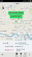
→ Online map services (Open Street Maps, Hybrid Maps, Satellite Maps, Terrain Maps..) Online maps can be prepared using QuickMapServices plugin in QGIS. You can add Open Street Maps, hybrid or satellite maps in QGIS project for Surveying Calculator.
→ Geodatabase (GeoPackage, Spatialite) formats in QGIS projects.
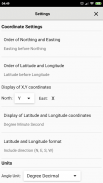
- Coordinate System support:
→ Supports 5000 different EPSG coordinate systems.
→ User can search a coordinate system with country name or coordinate system name on epsg.io site. And user can create jobs with a proper EPSG code.
→ The coordinate system can be projected ( in feet or meters units) or geographic (in degree)
- Generate Coordinates: Generate coordinates in latitude/ longitude or in X, Y.
- Basic Surveying Tools: X(N), Y(E) Calculation, Distance, Azimuth Calculation, Interior Angle, Latitude Longitude from point, distance and bearing
- Intersection Methods: Forward Intersection, Line - Line Intersection, Circle by 3 Points
- Distance between Coordinates: 2D, 3D distance from X, Y and distance from Latitude, Longitude
- Area calculation from coordinates
- Degree - Decimal Conversion
- Coordinate Converter: WGS84 Latitude/Longitude to UTM XY or UTM XY to Latitude/Longitude Conventer, 2D Helmert transformation
- Settings: Coordinate order of northing, easting or latitude, longitude. DMS or decimal options for geographic coordinate systems. Scale bar unit settings in metric or imperial.
- and more.
Surveying Calculator supports Android 6.0 and up. Minimum 2GB RAM with 300MB free space are recommended.
Some of the new modules have bugs with the new update:
- Start Survey: The app sometimes closes unexpectedly when GPS button is active. To prevent this problem, turn off GPS mode before exiting Start Survey.
- Scale bar sometimes gives wrong results after adding layers and storing points.
- Projects sometimes display rotated map on Start Survey and Map View.
- Points are sometimes not recorded in Geopackage format.
It is planned to fix the weird bugs for next updates.
If you need help or if you have any suggestion about this app please mail to geosoft@gmail.com or join Surveying Calculator Facebook group to ask questions. You can follow news about the app on Facebook Page:
fb.me/surveyingcalculator
تستخدم حاسبة المسح عادةً أدوات مسح الأراضي. يتضمن ذلك حسابات هندسة الإحداثيات ، وجمع بيانات النقاط غير المتصلة بالإنترنت ، وعرض بيانات CAD ، GIS ، البيانات النقطية والخرائط عبر الإنترنت بتنسيق مشروع QGIS 3. حاسبة المسح تدعم مشاريع QGIS 3. (qgs ، qgz)
ميزات :
- Jobs:
وrarr؛ إنشاء وظائف غير محدودة لجمع النقاط في تنسيقات SHP أو GeoPackage مع رمز نظام الإحداثيات (رمز EPSG).
وrarr؛ يمكنك أيضًا إعداد وظيفة في QGIS على سطح المكتب باستخدام البيانات الجغرافية المكانية. استيراد CAD ، GIS ، البيانات النقطية أو إضافة خدمات الخرائط عبر الإنترنت في QGIS. ونقل مجلد البيانات إلى مجلد Surveying_Calculator / projects على جهازك. حدد المشروع في الوظائف وابدأ الاستطلاع.
- بدء المسح:
وrarr؛ جمع نقاط غير محدودة مع "الاسم" و "الوصف". يمكنك تسجيل موقعك أو أي مكان تريده.
وrarr؛ إضافة نقطة مع الإحداثيات (س ، ص أو خط العرض ، خط الطول).
وrarr؛ اجعل عملية المسح سهلة باستخدام مشاريع QGIS.
- عارض الخريطة: يعرض مشاريع QGIS 3.
وrarr؛ من الممكن تضمين البيانات الجغرافية المكانية لعرض الخرائط على هذا التطبيق ؛
وrarr؛ Raster (GeoTIFF ، DEM ، JPEG ، PNG ، GRD ، XYZ ، ..) ،
وrarr؛ CAD (DXF ، DGN v7) ،
وrarr؛ GIS (ArcGIS shp ، Google Earth (kml ، kmz) ، GeoJSON ، GPX ..) ،
وrarr؛ خدمات الخرائط عبر الإنترنت (خرائط الشارع المفتوحة ، والخرائط المختلطة ، وخرائط الأقمار الصناعية ، وخرائط التضاريس ..) يمكن إعداد الخرائط عبر الإنترنت باستخدام البرنامج المساعد QuickMapServices في QGIS. يمكنك إضافة خرائط الشارع المفتوحة ، والخرائط المختلطة أو الأقمار الصناعية في مشروع QGIS لـ حاسبة المسح.
وrarr؛ تنسيقات قاعدة البيانات الجغرافية (GeoPackage ، Spatialite) في مشاريع QGIS.
- تنسيق دعم النظام:
وrarr؛ يدعم 5000 أنظمة تنسيق EPSG مختلفة.
وrarr؛ يمكن للمستخدم البحث في نظام الإحداثيات باسم البلد أو تنسيق اسم النظام على موقع epsg.io. ويمكن للمستخدم إنشاء وظائف برمز EPSG المناسب.
وrarr؛ يمكن إسقاط نظام الإحداثيات (بالأقدام أو وحدات متر) أو جغرافيًا (بدرجة)
- إنشاء إحداثيات: إنشاء إحداثيات في خطوط الطول / الطول أو في X ، Y.
- أدوات المسح الأساسية: حساب X (N) و Y (E) والمسافة وحساب السمت وزاوية داخلية وخط طول خط العرض من النقطة والمسافة وتحمل
- طرق التقاطع: التقاطع الأمامي ، تقاطع الخط - الخط ، الدائرة بـ 3 نقاط
- المسافة بين الإحداثيات: 2D ، المسافة ثلاثية الأبعاد من X ، Y والمسافة من Latitude ، Longitude
- حساب المساحة من الإحداثيات
- الدرجة - التحويل العشري
- محول الإحداثيات: WGS84 خط العرض / خط الطول إلى UTM XY أو UTM XY إلى Latitude / Longitude Conventer ، تحويل 2D Helmert
- الإعدادات: تنسيق ترتيب الشمال أو الشرق أو خط العرض ، خط الطول. DMS أو الخيارات العشرية لأنظمة الإحداثيات الجغرافية. إعدادات وحدة شريط النطاق في متري أو إمبراطوري.
- وأكثر من ذلك.
مسح حاسبة يدعم أندرويد 6.0 وما فوق. يوصى بحد أدنى 2 جيجابايت من ذاكرة الوصول العشوائي (RAM) مع مساحة خالية تبلغ 300 ميجابايت
تحتوي بعض الوحدات الجديدة على أخطاء في التحديث الجديد:
- بدء المسح: يغلق التطبيق أحيانًا بشكل غير متوقع عندما يكون زر GPS نشطًا. لمنع هذه المشكلة ، قم بإيقاف تشغيل وضع GPS قبل الخروج من بدء المسح.
- شريط النطاق في بعض الأحيان يعطي نتائج خاطئة بعد إضافة طبقات وتخزين النقاط.
- مشاريع في بعض الأحيان عرض خريطة استدارة على بدء المسح وعرض الخريطة.
- لا يتم تسجيل النقاط أحيانًا بتنسيق Geopackage.
تم التخطيط لإصلاح الأخطاء الغريبة للتحديثات التالية.
إذا كنت بحاجة إلى مساعدة أو إذا كان لديك أي اقتراح حول هذا التطبيق ، فيرجى إرسال بريد إلكتروني إلى geosoft@gmail.com أو الانضمام إلى مجموعة Facebook Surveyor Calculator Facebook لطرح الأسئلة. يمكنك متابعة أخبار التطبيق على صفحة Facebook:
fb.me/surveyingcalculator
Surveying Calculator - إصدار 3.5.4
(08-02-2021)Surveying Calculator - معلومات APK
نُسخة APK: 3.5.4الحزمة: org.project.geoclassتطبيقات من الفئة نفسها
قد يعجبك أيضًا...


